World-reforestation monitor use case community conservation Campeche, Mexico
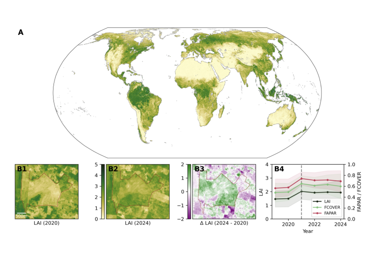
This use case supports community-led conservation projects, by providing high-resolution maps of vegetation traits like LAI, FAPAR, and FCOVER, derived from Sentinel-2 data. Using the PROSAIL model, the maps track restoration progress with annual updates from 2019–2024 at up to 20m spatial resolution. These data empower local efforts to monitor ecosystem recovery and inform biodiversity conservation.
Monitoring ecosystem restoration on a global scale is complex due to the computational demands and domain knowledge required to process high-resolution, high-frequency remote-sensing data. Moreover, while satellite imagery provides a wealth of surface-level information, directly connecting these observations to ecological conditions, such as vegetation structure and function, remains a challenge. This link is essential for accurately describing and evaluating the current state of vegetation and its trajectory under restoration.
Our solution
To overcome these challenges, we have developed annual, high-resolution global maps of vegetation traits and biophysical variables derived from Sentinel-2 imagery through inversion of the PROSAIL radiative transfer model. These pre-computed products, available for the years 2019–2024, include the effective leaf area index (LAIe), the fraction of absorbed photosynthetically active radiation (FAPAR), and the fraction of vegetation cover (FCOVER). We demonstrate the usage of the generated products for an exemplary site in the Yucatán Peninsula’s Mayan Forest, which aims to restore biodiversity, enhance carbon sequestration, and support local livelihoods.
Monitoring reforestation – an example from Campeche, Mexico. (A) Global LAIe, 2022; (B) Site-level analysis, showing pre-intervention (B1), post-intervention (B2), change maps (B3), and aggregated site-level trends (B4)
Who will benefit?
This work directly supports restoration practitioners, conservationists, policymakers, and researchers by providing consistent, high-resolution global datasets that simplify and strengthen ecosystem monitoring. By integrating these data into platforms like Restor.eco, restoration efforts worldwide can be more effectively tracked, communicated, and evaluated—ultimately empowering those on the ground to demonstrate their impact and make informed decisions.