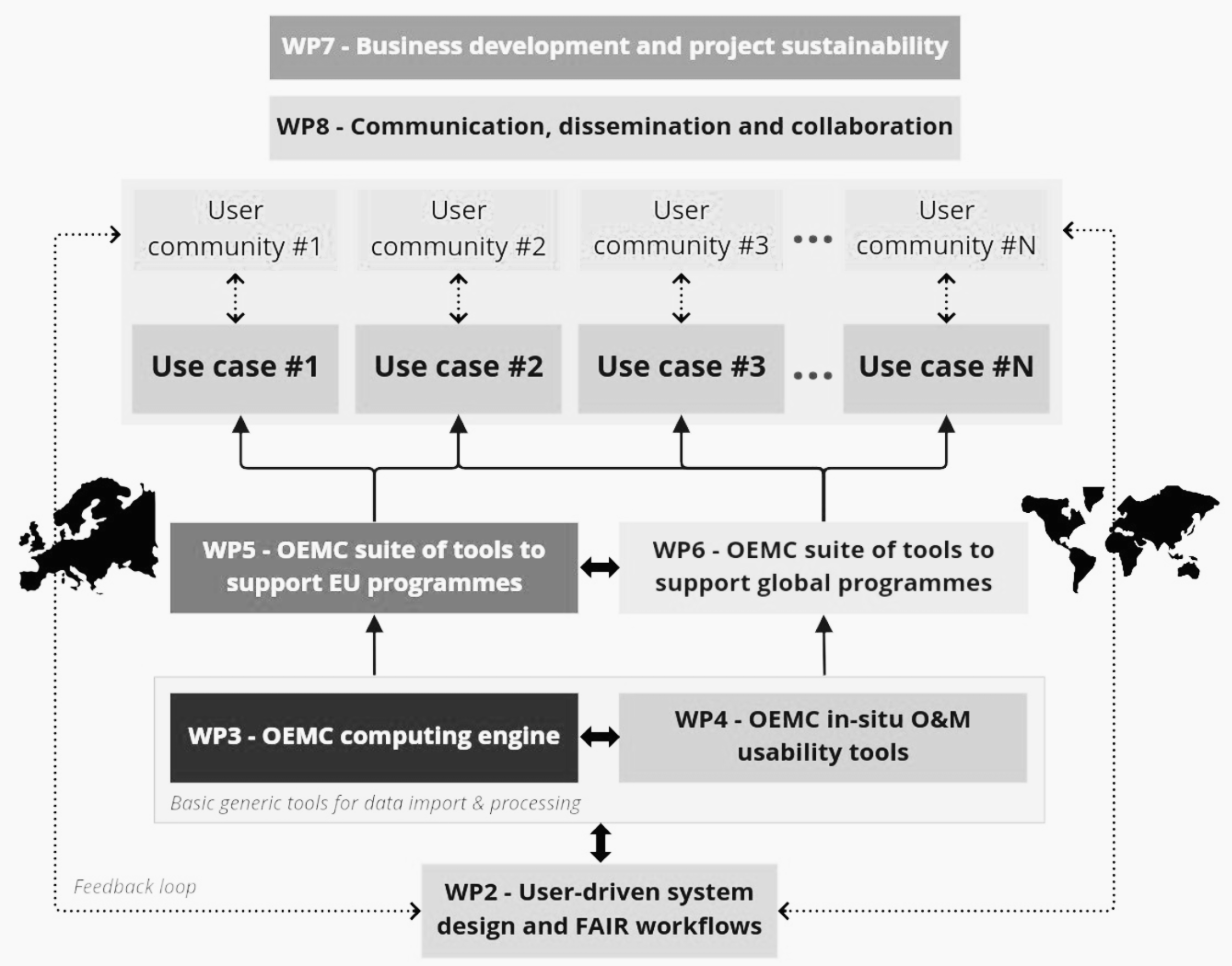
Open-Earth-Monitor Cyberinfrastructure

The Open-Earth-Monitor project aims to build a F.A.I.R.-compliant cyberinfrastructure to accelerate the uptake of environmental information and help build user communities at European and global levels.

Funded by the Horizon-Europe programme of the European Commission, a consortium of 23 partners led by the OpenGeoHub foundation will provide operational solutions and decision-making tools for European and global initiatives such as DestinE, Digital Twin Initiative, Fit for 55, UN sustainable development goals and more.

Key project deliverables and components of the cyberinfrastructure are:
1) Stakeholder committee and user engagement plans throughout the project’s entire duration; 2) High-performance computing engine and on-site data services; 3) Tools directly serving EU citizens and governance needs via easy-to-use data portals and apps; 4) Tools serving global governance needs.

Open-Earth-Monitor in a nutshell

Project Consortium: 23 Partner organizations
Funding: 12,701,292.84 EUR
Period: 1 June 2022 - July 2026
Call: (HORIZON-CL6-2021-GOVERNANCE-01)

Project outputs

Working Packages

Open-Earth-Monitor is a multidisciplinary project. The consortium includes diverse partners, connecting European institutes at the frontier of data science and land monitoring.

This WP is dedicated to the organization and leadership of the project, organising project meetings, making action plans, discussing and distributing decisions, producing working and official project documents (technical and financial reports), and organizing the overall project management.

WP2 ensures the close connection of all project activities to stakeholder needs and to maximise the impact and uptake FAIR environmental data by: (1) Establishing a multi-layered stakeholder dialogue structure and engaging them throughout the project, (2) Collecting and analysing EU and national level stakeholder needs and preferences, (3) Analyse the status of FAIR environmental.

WP3 aims to build generic tools that can then be used in WPs 5-6, specific objectives include: (1) to develop generic data science, Earth Observation / data cube processing tools built on top of existing services (DIAS, xcube processing service, openEO, EuroDataCube, Sentinel Hub), (2) to increase user-engagement by enabling easier access to data, (3) to provide specialised libraries that can be used to generate value-add data from EO (remote sensing data cubes) and in-situ (training points) data, (4) to provide tailored tools to support Agriculture Knowledge and Innovation Systems (AKIS).

The heterogeneity of in-situ observations in terms of type, format, access and usability is addressed in this WP identifying, processing and making them accessible and usable in and outside the project through (1) ensuring data FAIRness and access in consolidated repository and observation networks, (2) increase the level of FAIRness and ensure access in standard format to (meta) data from other existing networks, (3) evaluate the potential and make data accessible for new observatory platforms not yet routinely used in synthesis and integrative activities like the one proposed in the project.

This WP (1) provides a generic framework for visualization of environmental information (tools to users to get data insights in a user-friendly manner), (2) develops a front-end solution (data portal) to enable users to access in situ data produced in WP4, and (3) develops a data and analysis portal (based on the European Terrestrial Reference System / ETRS89) serving EU governance and supporting EU programmes.

This WP aims (1) to develop a suite of tools and datasets based on the OpenEM engine (WP3 and WP4) that demonstrate its capacity to monitor the state of the planet and to support global programmes (eg. GEOSS and UNFCCC); and (2) to provide global datasets (in Equi-7 and WGS84 systems) that can contribute towards making data-driven diagnostics of the state of the Earth, which can support the development of Digital Twins of the Earth under the DestinE initiative.

WP7 is dedicated to

(1) define tailored and fit-for-purpose data governance structures that enable fair and efficient post-project exploitation by all interested parties;

(2) follow and check all project outcomes that they: (a) are compatible, (b) match in spacetime, (c) follow the FAIR principles and (d) do not pose potential threats to the environment derived from AI/model systems;

(3) iteratively develop a clear business strategy to transition to post-project operations of cloud-based services in compliance with all relevant legislations (e.g. Artificial Intelligence Act); (4) ensure project outcomes contribute to expected impacts and to ensure sustainable use of project results.

WP8’s objectives are (1) to enhance communication, dissemination and collaboration within the project and externally, (2) to establish and follow-up the communication and dissemination strategy, (3) to maintain project media including website, newsletters and public presentations, (4) to organise and manage events including workshops and hackathons, (5) to enable and assist publication of research outputs (through multimedia production).

RESEARCH AND INNOVATION ACTIVITIES

Supporting European and global programmes and initiatives

Once operational, Open-Earth-Monitor could be used to significantly improve existing environmental data products and services, and also to produce next-generation datasets that can directly support the implementation of European sustainability policies, digital transitions and climate adaptation measures.

OEMC will produce solutions that could significantly contribute to the ongoing EU Digital Twin Earth initiatives (e.g. DestinE in collaboration with ESA, EUMETSAT and ECMWF).

We plan to develop several global solutions to directly support GEOSS programmes, strongly focussing on nature-based solutions to the climate emergency.

GOVERNANCE

Stakeholder committee

  • Rochelle Schneider
    Artificial Intelligence Applications Lead at European Space Agency
  • Gert-Jan Nabuurs
    Professor of European Forest Resources at Wageningen University
  • Gilberto Camara
    INPE
  • Raymond Sluiter
    Senior Advisor Data & Applications at the Netherlands Space Office
  • Peter Strobl
    Senior Scientific Officer at the Joint Research Centre of the European Commission
  • Hannes Reuter
    Statistical Officer at the European Commission
  • Paola De Salvo
    Information Technology Officer at the GEO Secretariat
  • Patrick Griffiths
    EO Data Engineer at the European Space Agency
  • Julia Wagemann
    Independent consultant on Big Earth data and cloud-based services
  • Barron Joseph Orr
    Lead Scientist for the United Nations Convention to Combat Desertification (UNCCD)
  • Florian Franziskakis
    In-Situ Data Management Specialist at EuroGEO
Research and innovation activities

Building upon various Horizon and ESA projects

Open-Earth-Monitor builds on multiple active and past Horizon and international projects where consortium members are either acting as leads or have contributed significantly. This project comes with high ambitions exactly because it is rooted in almost €100 million of existing EU funding. Connected projects include: ICOS, ENVRI-FAIR, LifeWatch, USMILE, COS4Cloud, LandSense, Euro Data Cube, Global Earth Monitor, AgriCapture, MAIA, Geo-wiki.org, DCS4COP, Restor.eco, Dione, OpenEO H2020 , OpenDataScience.eu, TreeTalker network, CCI Snow and many others.