Global EO data to support monitoring livestock and grasslands / pastures
This use case has two stakeholders, LAPIG and WRI, which are part of Global Pasture Watch (GPW), a Land & Carbon Lab initiative, together with OpenGeoHub and IIASA. LAPIG is involved in multiple mapping initiatives in global tropics and they are interested in downscaling Landsat-based maps to 10-m using Sentinel-2 data. WRI is interested in a dashboard to provide the means to integrate on-the-fly the GPW maps (pasture-class, livestock density, short vegetation height and gross primary gross productivity-GPP) through spatial and pixel threshold filtering, allowing the implementation of IPCC land degradation criteria for multiple users. The use case will support the production, calibration and visualization of recurrent 30-m mapping products for grasslands/pasture areas and livestock from 2000 onward within the context of GPW, aiming to contribute for a better understanding of land use conversion, food production, climate change and land productivity at global scale. All produced EO data and training samples will be open data allowing further refinements for the mapping products at national and local scales by user communities. This use case specifically demonstrates how analysis-ready products can be generated and distributed using open source software solutions and cloud-optimized formats for large data.
Monitoring grasslands and livestock at a global scale is challenging due to the need for high-resolution data and the integration of different data sources. Many existing products lack the detail needed for local analysis and decision-making.
Our solution
This use case provides a dashboard that integrates pasture maps, livestock density, and productivity metrics at 10m to 30m resolution. The system supports customized filtering and data visualization, enabling users to assess land productivity and meet IPCC land degradation criteria.
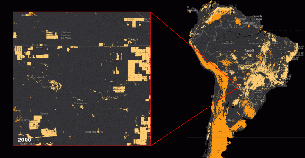
The expansion of pastureland in Brazil over the last 20 years.
Pasture managers, policymakers, and conservation organizations will benefit from better insights into grassland conditions and sustainable land management.