Biodiversity monitoring and reporting tools for IDH
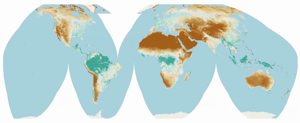
This use case will build tools for monitoring and reporting on biodiversity trends, aiming to support impact investment in sustainable agriculture and forestry. The tools will provide a global overview of biodiversity trends at any site for the last 25+ years, primarily based on Earth Observation (EO) data, and can be used in combination with local data to refine and improve estimates. The goal is to deliver high spatial resolution data that can be used to track biodiversity impacts and changes for specific farms or areas where investments are being made. The data will be based on a combination of indicators such as FPAR (Fraction of Absorbed Photosynthetically Active Radiation) monthly, fire disturbance monthly, canopy height, vegetation diversity, bare earth and surface water percentage.
What is the challenge?
Current methods for assessing the impact of investments in agriculture and forestry on biodiversity are often inadequate. There is a lack of readily available, high-resolution data and tools that can be used to reliably track changes in biodiversity over time. Existing data is often difficult to interpret, analyze and use, especially for those lacking specific technical expertise. The ecosystem of impact investment lacks concrete evidence of positive impacts of financing. Quantifying positive impact on biodiversity and assessing how well natural forests are conserved is difficult. There is a need for tools that can distinguish between different types of land use, for example between natural forests and plantations, and can determine which practices have better outcomes for biodiversity.
Our solution
This use case provides a set of tools and data that enable stakeholders to monitor and report on biodiversity trends at a high spatial resolution. The tools are designed to be easy to use and can be applied to various types of projects. The project also aims to address the need for transparency and accountability in impact investment, by offering a way to independently validate claims of positive biodiversity impacts. The aim is to provide easily usable data that can be used to monitor large areas in tropical areas and assess historical levels of deforestation and land use.
Global map of Fraction of absorbed photosynthetically active radiation (FAPAR)
Who will benefit?
Impact investment companies and their investors will benefit from the ability to track and report on the biodiversity impacts of their investments. Environmental NGOs, policymakers, and researchers working on conservation projects, especially in developing countries, will benefit from access to improved biodiversity insights.